


Zimbabwe knows it is rich in minerals. What it does not yet know, with enough precision, is where all of that wealth lies.
Across large stretches of the country, the geological picture remains incomplete, leaving potentially prospective ground outside the focus of serious exploration. Now, the government is betting that better geological data can help redraw that map and, in the process, point explorers towards Zimbabwe’s next generation of mineral discoveries, Mining Zimbabwe reports.
By Ryan Chigoche
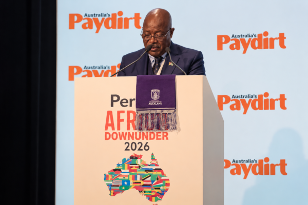
Speaking after Zimbabwe’s participation at the Africa Down Under conference in Perth, Deputy Minister of Mines and Mining Development Dr Caleb Makwiranzou acknowledged that exploration has not kept pace with the country’s mineral endowment.
“We have also told them that exploration is not being commensurate with the minerals that we have, the number of minerals,” Makwiranzou said.
With more than 60 minerals identified in Zimbabwe, the Government believes there is room to broaden the country’s exploration frontier beyond the commodities that currently dominate its mining sector.
“With over 60 minerals, in part of which are commercially extractable, we think that we could work with serious explorers through modern geological surveys, using airborne surveys and getting geoscience data,” he said.
That shift towards better geological intelligence is central to the next phase of Zimbabwe’s mining ambitions.
The country has significant geological information already, but large areas remain underexplored and investors often face the same fundamental question before committing capital: where is the mineralisation, and how confident can they be about its potential?
Modern geophysical surveys can help narrow that uncertainty.
Rather than relying solely on surface observations and individual exploration programmes, airborne surveys can cover large areas and identify geological structures and anomalies that may warrant closer investigation. For a country seeking to attract more exploration capital, the value is not simply in producing another geological map, but in giving investors better information on where to take their next risk.
The Government’s planned nationwide geomagnetic airborne survey is intended to strengthen that geological knowledge base, while the National Development Strategy 2 also envisages broader use of airborne geophysics, satellite imagery and geographic information systems to improve mineral information and focus exploration on underexplored areas.
Makwiranzou’s comments in Perth suggest the programme is increasingly being viewed not just as a technical exercise, but as an investment tool.
The response from investors at Africa Down Under reinforced that point.
The Government is now looking to turn those conversations into targeted follow-ups.
“Thirdly, we have been allocating names to specific commodities so that investors can be able to follow up when the conference is finished,” he said.
“We have also invited explorers to register their interest in our geoscience program.”
That creates a potentially important feedback loop: investors indicate what they are looking for, Government improves the geological information available, and explorers use that information to identify where further work may be justified.
The ambition is ultimately to move from fragmented geological information to a more integrated picture of Zimbabwe’s mineral wealth.
Under the country’s broader digital transformation plans, Government has also proposed a National Mineral Information System that would bring together geological data, exploration licences and production information, while linking with systems such as the mining cadastre.
For explorers, the significance is straightforward. Better data can reduce the amount of uncertainty that has to be absorbed before drilling begins.
A drill rig is one of the most expensive ways to ask a geological question. The more that can be understood before the rig arrives, the better positioned investors are to decide where to spend money.
And that matters as Zimbabwe seeks to attract exploration into minerals that could become increasingly important in global supply chains.
Lithium has already demonstrated how quickly a previously less prominent mineral can become central to the country’s mining story. The next wave could involve graphite, rare earth elements and other critical minerals — but identifying commercial deposits requires more than simply knowing that the minerals occur in Zimbabwe.
It requires knowing where the most prospective ground is, how extensive the deposits may be and whether they can ultimately support commercially viable projects.
That is where the geological mapping push becomes more than a question of data.
It becomes part of the country’s pitch to explorers.
The challenge, however, will be turning geological intelligence into actual exploration, discoveries and eventually mines. Airborne surveys can identify targets, but they cannot replace fieldwork, drilling, feasibility studies and the capital required to develop a deposit.
The Government’s task will therefore be to ensure that improved geological information translates into exploration activity on the ground.
Makwiranzou’s message in Perth was also clear that any discoveries are expected to feed into a broader industrial strategy rather than simply create another source of raw mineral exports.
“We have stressed, however, that we have moved away from exporting ore. We are exporting processed minerals,” he said.
“We want to export lithium sulfate and other such finished products.”
The objective is to use mineral processing as a foundation for industries such as battery manufacturing, creating more value within Zimbabwe rather than allowing the country’s mineral wealth to leave at the earliest stage of the supply chain.
That makes the search for new deposits part of a much larger equation.
Zimbabwe is not simply trying to find more minerals. It is trying to understand its geological endowment better, attract capital into the parts of it that remain unexplored, and build an industrial base around the resources that prove commercially viable.
The success of that strategy will ultimately be measured not by the number of surveys completed or geological datasets generated, but by what follows: more exploration licences, more drilling, new discoveries, new mines and new processing industries.